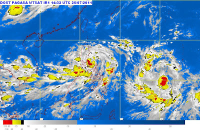
Bagyong Juaning PAGASA Update - July 26, 2011
Posted by has in bagyong juaning, bagyong juaning july 26 2011, bagyong juaning updates, juaning, PAGASA, pagasa update july 26, tropical storm juaning on Monday, July 25, 2011
Bagyong Juaning (Tropical Storm Juaning) has intensified further and slowed down as it continues to threaten Southern and Central Luzon including Metro Manila, the PAGASA said Tuesday evening.
According to the bulletin released by the PAGASA at 11 p.m. today, Bagyong Juaning now has maximum winds of 85 kph near the center and gustiness of up to 100 kph. It is moving at 11 kph in a West Northwest direction and was located at 70 km North Northwest of Daet, Camarines Norte at 10p.m..
Public Storm Warning Signals have been hoisted over the following areas:
Signal No. 2:
Camarines Provinces
Camarines Provinces
Albay
Catanduanes
Aurora
Quirino
Nueva Vizcaya
Benguet
La Union
Pangasinan
Nueva Ecija
Zambales
Pampanga
Tarlac
Bulacan
Bataan
Rizal
Cavite
Laguna
Batangas
Quezon
including Polillo Island
and Metro Manila
Signal No. 1:
Ilocos Norte
Ilocos Sur
Apayao
Cagayan
Abra
Kalinga
Isabela
Mt. Province
Ifugao
Mindoro Provinces
Lubang Is.
Marinduque
Romblon
Burias Is.
Masbate
Ticao Is.
Sorsogon
The PAGASA warns those residing in low lying and mountainous areas under signals No. 1 and 2 of possible flashfloods and landslides. Those living in coastal areas are also alerted against big waves or storm surges generated by this tropical cyclone.
Tropical Storm Juaning is expected to enhance the Southwest Monsoon and to bring widespread rains over the Rest of Luzon and Western Visayas.
Meanwhile, Wednesday classes have been suspended by DepEd in many areas in Luzon. Check the details here: http://noypistuff.blogspot.com/2011/07/suspension-of-classes-on-july-27-2011.html
This entry was posted on Monday, July 25, 2011 at 6:37 PM and is filed under bagyong juaning, bagyong juaning july 26 2011, bagyong juaning updates, juaning, PAGASA, pagasa update july 26, tropical storm juaning. You can follow any responses to this entry through the RSS 2.0. You can leave a response.
- No comments yet.
