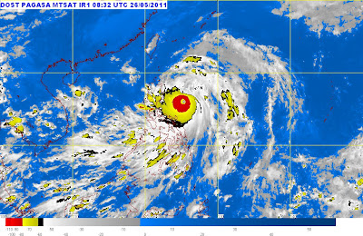
Bagyong Chedeng Update from PAGASA - May 26, 2011
Posted by has in bagyong chedeng, bagyong chedeng may 26 2011, news, PAGASA, PAGASA Weather Forecast, tropical storm chedeng, typhoon chedeng on Wednesday, May 25, 2011
Bagyong Chedeng Update - May 26
Bagyong Chedeng "has slightly intensified as it continues to move northwestward", PAGASA's latest Typhoon Chedeng bulletin reads.
Check out below the said PAGASA update on Tropical Storm Chedeng:
***Bagyong Chedeng May 27, 2011 Update:
http://noypistuff.blogspot.com/2011/05/bagyong-chedeng-update-may-27-2011.html
Severe Weather Bulletin No. 14
Tropical Cyclone Warning: Typhoon "CHEDENG" (SONGDA)
Issued at 5:00 p.m., Thursday 26 May 2011
Issued at 5:00 p.m., Thursday 26 May 2011
Typhoon "CHEDENG" has slightly intensified as it continues to move northwestward.
| Location of Center: (as of 10:00 a.m.) | 260 km North Northeast of Virac, Catanduanes or at 300 km East Southeast of Casiguran, Aurora |
|---|---|
| Coordinates: | 15.8°N,125.4°E |
| Strength: | Maximum sustained winds of 175 kph near the center and gustiness of up to 210 kph |
| Movement: | Northwest at 19 kph |
| Forecast Positions/Outlook: | Friday afternoon: 320 km North Northeast of Casiguran, Aurora or at 200 km East Northeast of Aparri, Cagayan Saturday afternoon: 590 km Northeast of Basco, Batanes or 190 km Southwest of Okinawa, Japan |
Signal Number 1
Catanduanes, Camarines Sur, Camarines Norte, Albay, Quirino, Aurora, Quezon provinces, Polilo Island, Isabela and Cagayan
Advisory
Residents in low lying and mountainous areas under #1 are alerted against possible flashfloods and landslides. Likewise, those living in coastal areas are alerted against big waves or storm surges generated by this tropical cyclone.
Typhoon “Chedeng” is expected to enhance the southwest monsoon and will bring rains over Visayas and Mindanao.
This entry was posted on Wednesday, May 25, 2011 at 10:40 PM and is filed under bagyong chedeng, bagyong chedeng may 26 2011, news, PAGASA, PAGASA Weather Forecast, tropical storm chedeng, typhoon chedeng. You can follow any responses to this entry through the RSS 2.0. You can leave a response.
- No comments yet.
